A First Loop Around an Unfamiliar Festival Site
A first loop around an unfamiliar festival site helps you read signs, understand how areas connect, and choose a useful route before settling in.
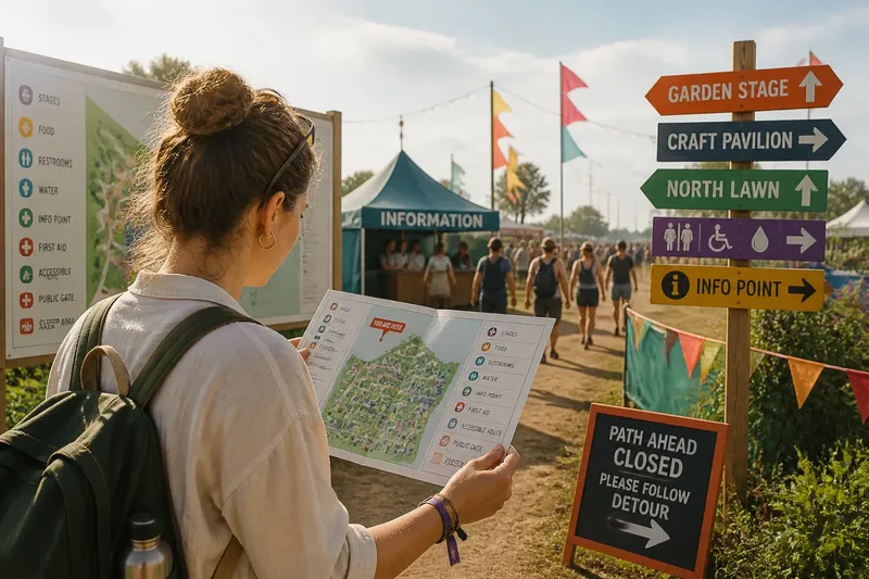
You pause just inside an unfamiliar festival gate, holding a folded map while music drifts from somewhere beyond the food stalls. A first loop around an unfamiliar festival site can help you understand how its areas connect, where signs are posted, and which route makes sense for your next stop.
This is less about collecting landmarks than learning how the site works. Notice the map’s orientation, how paths are marked, where public routes narrow or split, and whether the signs match what you see on the ground.
What should you read on the site map?
Start by finding the map’s “you are here” marker, then turn the map until its directions match the view in front of you. Look for the legend, which explains symbols for stages, restrooms, accessible routes, information points, and other facilities. A symbol is only useful if you know what it represents.
Next, trace the route between the places you may visit. Pay attention to path names, gates marked for public entry, one-way arrows, and any areas labeled closed or restricted. If a printed map and a posted notice appear to differ, follow current signs and ask festival staff to clarify.
How can signs help you understand the layout?
Use directional signs as confirmations at decision points: where paths branch, where a route changes direction, or where one festival area meets another. Rather than memorizing every turn, notice the sequence of signs and what each one names. This gives you a practical sense of how to retrace a route.
Look for repeated place names on both the map and the signs. If the map calls an area “North Lawn,” for instance, check whether a nearby sign uses that same name; consistent labels make it easier to tell which area you have reached. When signs are missing or unclear, stop somewhere that does not obstruct foot traffic and ask a staff member.
Which route details are worth checking?
- Map orientation: Check whether the map shows a compass or a “you are here” marker; if the symbols match your view, use the map to trace a route, but if they do not, turn the map or ask staff to orient you.
- Public gates: Check which entrances are marked for visitors; if a gate is identified as public, consider it as a route option, but if its status is unclear, do not assume it is open and ask staff.
- Path arrows: Check for one-way directions or route restrictions; if an arrow indicates your intended direction, follow it, but if it points elsewhere, choose a signed alternative.
- Area connections: Check whether a path links the places you plan to visit; if the map and signs both show a connection, use that route, but if they conflict, pause and confirm with staff.
- Access information: Check the map and posted notices for accessible routes and facility symbols; if the details suit your needs, use the marked route, but if something is missing or uncertain, ask the event’s access team or staff.
- Closed sections: Check for barriers and closure notices; if a route is open, continue as directed, but if it is closed, follow the marked detour rather than trying to pass through.
- Information points: Check where an information tent or staffed desk appears on the map; if you need help interpreting the layout, head there, but if it is not nearby, ask an identifiable staff member.
Keep the map handy until you have confirmed the names and connections of the areas that matter to your plans.
How should you adapt the loop to your arrival?
If you arrive alone, use the map to locate an information point and the route back to a public gate. If you arrive with others, compare the map’s place names together so everyone uses the same terms when choosing where to go.
If the grounds are crowded, avoid crossing against the direction of moving foot traffic just to inspect another section. Follow a clear sign toward an open route or staffed point, then continue exploring when the path allows.
If someone in your party needs an accessible route or frequent pauses, check the relevant map symbols and posted access information before choosing a direction. Ask staff about details the map does not make clear, since routes and facilities vary by event.
What questions do festival maps and signs raise?
What should you do if the map and signs disagree?
Follow current on-site directions, especially notices about closures or changed routes, and ask festival staff to resolve any uncertainty. Do not cross a barrier or enter a restricted area because an older map appears to show a path.
How can you tell whether a gate is for public use?
Look for an entrance sign or a map label that identifies the gate as a public entry or exit. If there is no clear marking, ask staff rather than treating a visible opening as an authorized route.
What if a place name is hard to match?
Compare nearby signs with the map legend and labels, and check for a named landmark or area marker. If the names still do not line up, ask at an information point before walking farther in the wrong direction.
Do you need to learn the whole site on your first loop?
No. Focus on the route to your next destination, the signs that confirm it, and any access or closure information that affects your plans. You can consult the map again when you decide to visit another area.
When is the route clear enough to follow?
Imagine you enter beside a map showing the craft pavilion and a garden stage, with a public path marked between them. You turn the map to match the entrance, follow two signs naming the garden stage, and then notice a closure notice at the path junction. You take the signed detour instead; the result is a clear route that respects the current closure, even though it is not the line originally shown on the map.
Before leaving the entrance area, check that you can name your destination, identify the next sign or junction, and recognize any restriction on the route. Keeping the map accessible lets you verify the next connection without having to reconstruct the whole site from memory.
A first loop around an unfamiliar festival site is useful when it teaches you how to read that particular place, not when it covers every path. Follow current signs, confirm unclear access details with staff, and keep the map where you can consult it before the next turn.